Laufende Masterarbeiten
-
Leveraging uncertainty information to refine semantic segmentation for port and marine structures in the CNN contextEstimation of the prediction uncertainty of previous trained segmentation networks and introduction of this information to the learning process of a new (modified) model instance to refine damage detection maps.Led by: Marvin Scherff, Frederic Hake, Hamza AlkhatibTeam:Year: 2024Duration: 03/2024 - 09/2024
![]()
![]() © Scherff
© Scherff
-
Strategies for lowering the net land take in Germany and selected countries in the EUIn Germany, the net land take in 2020 was 54 Hectares per day – mostly used for housing, industry and commerce (excluding extraction areas), public facilities. The German National Sustainability Strategy set the goal to reduce the net land take to 30 Hectares per day in 2020. This political goal was failed by far. The current political goal is to reduce the net land take to below 30 Hectares per day in 2030. Therefore, it is important for local planning authorities (municipalities) to change their strategies in urban development planning (e.g. brownfield development instead of greenfield development). In this thesis, different strategies and approaches for reducing the net land take used for urban development planning should be analysed and compared.Led by: Jörn Bannert, Winrich VoßTeam:Year: 2024Duration: 09/2024 - 03/2025
-
Qualitative comparison of the products "Deutschlandatlas" and "Landatlas" for different user groupsIn Germany, two web-based products are available: “Deutschlandatlas” and “Landatlas”. These products are available for different groups of user. These resources are very valuable in a lot of different circumstances. The question that different user-groups are constantly asking themselves is which one is the best for their specific purpose. The aim of this study is to conduct a comparative analysis of the “Deutschlandatlas” and “Landatlas” focusing on their data, thematic coverage, actuality, geographical specificity and user interface design.Led by: Robin Dankowski, Jörn Bannert, Winrich VoßTeam:Year: 2024Duration: 03/2024 - 09/2024
-
Strategic Municipal Heat Planning for Climate-Friendly and Cost-Efficient Heat SupplyGermany aims to have climate-neutral heating by 2045. Municipal heating planning informs citizens and businesses whether they can expect a district heating connection or should opt for another climate-friendly heating option. The Heat Planning Act came into force together with the Renewable Heating Act on January 1st 2024. The Heat Planning Act came into force together with the amendment to the Building Energy Act on January 1st 2024. Both laws will help to achieve the climate targets in 2045. For the first time, all cities and municipalities in Germany will have local heat planning. This will give citizens, companies and energy suppliers certainty as to whether and which centralised heat supply they can count on locally.Led by: Jörn Bannert, Winrich VoßTeam:Year: 2024Duration: 03/2024 - 09/2024
-
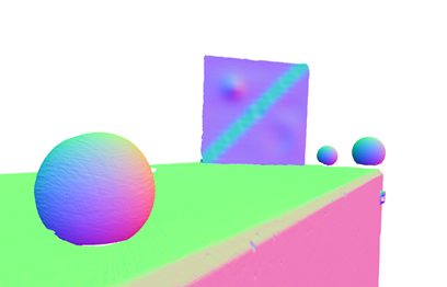
Deep Learning-based Downsampling and Semantic Segmentation of LiDAR Data for Urban Localization of Autonomous VehiclesIn the context of autonomous driving, localizing a vehicle in an urban environment is challenging due to dense infrastructures that disrupt satellite signals from Global Navigation Satellite Systems like GPS. To overcome this burden, LiDAR sensors can be deployed as they provide precise environmental scans that enhance localization accuracy, but they pose also significant challenges in real-time applications. Therefore, the examined approach in this thesis streamlines two common processes—downsampling and segmenting LiDAR data—into a singular, optimized model using advanced Deep Learning techniques. This innovative framework not only reduces computational load but also enhances the real-time capabilities of vehicle localization systems. The Deep Learning model and its training strategy are steered by a downstream localization filter that evaluates the incorporated processed LiDAR point clouds, ensuring the system's effectiveness in urban navigation.Led by: Marvin Scherff, Rozhin Moftizadeh, Hamza Alkhatib, Marius LindauerTeam:Year: 2024Duration: 05/2024 – 11/2024
![]()
![]() © GIH
© GIH
-
Integrated Path Planning in an Extended Kalman Particle Filter Framework for Vehicle NavigationPath planning is essential for the efficient and safe navigation of autonomous vehicles in complex environments. This master thesis aims to compare various path planning approaches using a real-world dataset. The study will integrate these algorithms with an advanced particle filter to determine the most effective combination. The ultimate goal is to develop a framework that not only ensures reliable localization but also optimally derives the path for the robot to reach its destination.Led by: Rozhin Moftizadeh, Hamza AlkhatibTeam:Year: 2024Duration: 01.10.2024 - 01.04.2025
![]()
![]() © GIH
© GIH
-
Rewetting of raised bogs in Lower Saxony and Baden-WürttembergIn this thesis, the approach to the rewetting of raised bogs in Lower Saxony and Baden-Württemberg will be examined and the approaches compared.Led by: Jörn Bannert, Winrich VoßTeam:Year: 2023Duration: 09/2023 - 03/2024


Abgeschlossene Masterarbeiten
-
An Efficient Assignment Approach for Position Tracking Using LiDAR Point CloudsThe simplicity of the commonly used LoD-2 models and the computational complexity of the mesh-based assignment algorithm bring difficulties to real-time position tracking. To improve the efficiency of assignment for position tracking with ESKF, a voxel-based environment model together with an assignment approach was proposed. This approach can be applied to various datasets, because the model is generated only based on the distribution of the 3D points. The proposed approach was implemented into a position tracking process based on ESKF for an MSS. To test the performance, a model was generated from a 3D map point cloud and a simulated environment was built based on the model. Both the proposed approach and the previous assignment approach were tested in the simulated environment. The result showed the speed of assignment was effectively increased, but the accuracy of position tracking was affected. This indicates the voxel-based method is meaningful for reducing the computational cost. Unfortunately, the cause of the decrease in accuracy has not been thoroughly identified. The algorithm needs to be further improved to optimize its performance.Led by: Rozhin Moftizadeh, Dominik Ernst, Hamza AlkhatibTeam:Year: 2024Duration: 01/2024 – 06/2024
![]()
![]() © GIH
© GIH
-
Einfluss von LoD2 vereinfachten Geometrien auf die Georeferenzierungs-Performance eines autonomen Fahrzeuges mittels Sensordatenfusion von IMU und LiDARLed by: Holger Blume (IMS), Hamza Alkhatib, Mohamad Wahbah, Sören VogelTeam:Year: 2024Duration: 04/2024 - 10/2024
![]()
![]() © GIH / Ramme
© GIH / Ramme
-
Optimal quality related viewpoint planning of terrestrial laser scanningThe quality of terrestrial laser scanning (TLS) measurements is influenced by a number of factors. In particular, the scan geometry affects the TLS distance measurement. Besides, the quality of the TLS point clouds is influenced at different incidence angles. Moreover, the spot size and resolution of the TLS measurements are highly correlated with the incidence angle and the distance measurements, e.g. by flattering angle or increasing the distance measurements, the resolution decreases. Accordingly, the optimal viewpoint planning has a decisive role in the quality of the TLS point clouds.Led by: Jan Hartmann, Mohammad OmidalizarandiTeam:Year: 2023Duration: 06/2023 – 12/2023
![]()
![]() © gih
© gih
-
Optimal occlusion related viewpoint planning of terrestrial laser scanningThe completeness of an object survey by terrestrial laser scanners (TLS) is of decisive importance for the quality assessment. Due to possible occlusions, parts of the object cannot be recorded, which can lead to a loss of information. This can be solved by recording from multiple TLS viewpoints. Since a TLS measurement can take several minutes with high accuracy and resolution requirements, the number of possible viewpoints should be minimized as much as possible while maintaining a high level of completeness of the object recording. In this master thesis, a methodology for 3D viewpoint selection shall be developed and implemented, which minimize occlusion in the point cloudLed by: Jan Hartmann, Mohammad OmidalizarandiTeam:Year: 2023Duration: 06/2023 – 12/2023
![]()
![]() © Hartmann
© Hartmann
-
Uncertainty Modelling of Echosounder MeasurementsMobile mapping systems such as multicopter UAVs equipped with LIDAR sensors or ships equipped with sonar measurement systems are often used for rapid acquisition of large areas. Although the sensors are widely used, their uncertainty properties have not yet been thoroughly investigated. The aim of this master thesis is to develop a quality model for bathymetric sensors such as Echo soudners or bathymetric LIDAR.Led by: Bahareh Mohammadivojdan, Frederic HakeTeam:Year: 2023Duration: 07/2023 – 01/2024
![]()
![]() © Mohammadivojdan
© Mohammadivojdan
-
Ableitung von Bodenwerten aus Kaufpreisen bebauter GrundstückeBodenrichtwerte müssen mindestens alle zwei Jahre flächendeckend von den Gutachterausschüssen bereitgestellt, und vorwiegend im Vergleichswertverfahren bestimmt werden. In Gebieten mit geringem Transaktionsvolumen von unbebauten Grundstücken, sogenannten kaufpreisarmen Lagen, ist dies nicht möglich. Die Gutachterausschüsse müssen daher mit anderen Verfahren Bodenwertinformationen ermitteln.Led by: Jörn Bannert, Hamza AlkhatibTeam:Year: 2023Duration: 05/2023 - 11/2023
-
Improving the Prediction Accuracy of an Existing LSTM-RNN for Road TrajectoriesAs the proliferation of intelligent autonomous vehicles continues, the importance of accurately and reliably understanding the vehicle's position during its operation becomes increasingly prominent, especially in the realm of localization and navigation. While existing prediction models such as Long Short-Term Memory Recurrent Neural Networks (LSTM-RNN) have shown promising results, inaccuracies in input data may lead to erroneous predictions.Led by: Hamza Alkhatib, Ralf Hofmann (IAV), Dominik ErnstTeam:Year: 2023Duration: 07/2023 - 01/2024
![]()
![]() © GIH/Ernst
© GIH/Ernst
-
Dynamic lidar extrinsic calibration with automatic scene selectionLiDAR is one of the indispensable sensors for high-level autonomous driving, providing accurate 3D environment data for autonomous vehicles. Typically, autonomous vehicles are equipped with multiple LiDAR sensors to expand the field of view. Calibration is a critical step in using these sensors. It was shown that accurate calibration of LiDAR can be achieved using a SLAM (simultaneous localization and mapping) algorithm.Led by: Hamza Alkhatib, Sören Vogel, Dominik ErnstTeam:Year: 2023Duration: 07/2023 - 01/2024
![]()
![]() © GIH
© GIH
-
Untersuchungen von akkustischen Unterwasser-Scandaten zur Erkennung von SchadensbildernDie alternde Infrastruktur der See- und Binnenhäfen in Deutschland und der demografische Wandel erfordern neue Sichtweisen, Technologien und Methoden bei der Vorbereitung und Durchführung des Lifecycle-Managements. Die bisher personal- und zeitintensiven Arbeitsprozesse müssen durch neue automatisierte Mess- und Analyseprozesse ersetzt werden, um transparent und ressourceneffizient sowie betriebssicher handeln zu können.Led by: Ingo Neumann, Christian Hesse, Frederic HakeTeam:Year: 2023Duration: 12/2023 - 05/2024
![]()
![]() © HydroMapper
© HydroMapper
-
Quality Assured Deformation Analysis of Civil Infrastructures Using TLS Point CloudsTerrestrial Laser Scanning (TLS) has emerged as a pivotal technology in 3D data acquisition. Within this context, the assessment of deformations in civil structures through TLS point clouds has become a critical research area. The primary objective of this master's thesis is to conduct an extensive deformation analysis using TLS point clouds, with a focus on developing a robust quality modeling framework and assessing the significance of identified deformations. To achieve this, the study will investigate the integration of quality information into surface approximations techniques to improve the reliability of deformation analysis.Led by: Jan Hartmann, Mohammad OmidalizarandiTeam:Year: 2023Duration: 11/2023 - 05/2024
![]()
![]() © GIH
© GIH
-
Verwendung von maschinellem Lernen zur automatisierten Ermittlung von ImmobilienwertenIn dieser Arbeit sollen zwei verschiedene baumbasierte Ansätze (Random Forest und XGBoost) zur Prädiktion von Immobilienwerten angewendet werden und mit den Ergebnissen aus der klassischen multiplen linearen Regression verglichen werden. Ziel ist die Ermittlung von Verkehrswerten nach den in der ImmoWertV normierten Verfahren. Die ermittelten Verkehrswerte sollen also den Vorschriften zur Wertermittlung in Deutschland entsprechen oder zumindest zu einem vorläufigen Verfahrenswert führen. Als Datengrundlage werden Transaktionen für den räumlichen Teilmarkt Niedersachsen und für den sachlichen Teilmarkt Eigenheime (Ein- und Zweifamilienhäuser, Reihenhäuser sowie Doppelhaushälften) aus den Kaufpreissammlungen der Gutachterausschüsse für Grundstückswerte in Niedersachsen genutzt werden.Led by: Jörn Bannert, Hamza AlkhatibTeam:Year: 2023Duration: 07/2023 - 01/2024
-
Influence of energy efficiency and climate protection measures on real estate purchase pricesThe aim of this study is to investigate whether an existing energy performance certificate has an influence on the purchase price when selling real estate. If an influence can be proven, the amount of the influence is to be determined.Led by: Jörn Bannert, Winrich VoßTeam:Year: 2023Duration: 11/2023 - 05/2024
-
Model for burden sharing to optimise wind energy sites in a municipality or intermunicipallyIn the course of the energy transition, the implementation of new wind energy sites gains very high priority for the national government and the federal states. On the other hand, many municipalities and land owners follow the NIMBY-principle (not in my backyard). For balancing the different interest, a model for municipal burden sharing has to be developed in this thesis.Led by: Jörn Bannert, Winrich VoßTeam:Year: 2023Duration: 10/2023 - 06/2024
-
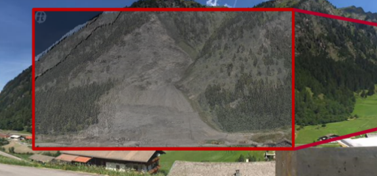
Refinement of DeepLabV3+ for Enhanced Crack Detection in Port InfrastructureThe ever-growing demand for maintaining the structural integrity of port infrastructure calls for advancements in automated inspection processes. With the advent of the Port AI project, the horizon of sensor platforms and intelligent software to scrutinize port infrastructures has significantly broadened. The integration of these advancements into Building Information Modeling (BIM) systems is poised to revolutionize the field of structural health monitoring. This master thesis aims to contribute to this transformative journey by focusing on image-based crack detection, a critical aspect of infrastructure inspection.Led by: Marvin Scherff, Hamza AlkhatibTeam:Year: 2023Duration: 11/2023 - 04/2024
![]()
![]() © GIH
© GIH
-
Comparison of methods for classification and segmentation of point clouds from Terrestrial Laser Scannerpoint cloud classification for surface fitting comparison of methods: Deap learning strategies, random forest based on Matlab and Cloud compareLed by: Gaël KermarrecTeam:Year: 2022Duration: 10/2021 - 04/2022
![]()
![]()
-
Gleisvermessung durch BefliegungDie Masterarbeit wird in Kooperation zwischen der DB Netz AG, dem Ingenieurbüro Nebel und Partner – Vermessung und Geoinformation sowie dem Geodätischen Institut durchgeführt. Hauptziel dieser Masterarbeit ist die Untersuchung, ob die Vermessungen im Felde durch Befliegungen ersetzt werden können und welche Rahmenbedingungen dafür einzuhalten wären.Led by: Arman Khami, Ingo NeumannTeam:Year: 2022Duration: 10/2021 - 04/2022
![]()
![]()
-
Untersuchung der Relationen zwischen Marktmieten und Bodenrichtwerten des inneren City-Ringes von HannoverIn der Bachelorarbeit sollen die Marktmieten für jede Bodenrichtwertzone mit einem geeigneten statistischen Verfahren ermittelt und zu dem entsprechenden Bodenrichtwert in Relation gesetzt werden. Ziel ist es, Gemeinsamkeiten oder Unterschiede im Preisniveau zwischen Marktmiete und (aus Kauffällen abgeleiteten) Bodenrichtwerten zu beziffern.Led by: Jörn Bannert, Winrich VoßTeam:Year: 2022Duration: 09/2021 - 03/2022
-
Erfassung einer hochgenauen Referenzpunktwolke zur Untersuchung von systematischen Effekten beim statischen LaserscanningBeim terrestrischen Laserscanning (TLS) können verschiedene Einflussfaktoren (z. B. Auftreffwinkel, Distanz, Material) zu systematischen Abweichungen in der Punktwolke führen. Mit Hilfe des Handscanners Leica LAS-XL soll eine geeignete Referenzumgebung aufgenommen werden, die eine umfassende Analyse der Unsicherheiten des TLS ermöglicht.Led by: Jan HartmannTeam:Year: 2022Duration: 11/2021 - 5/2022
![]()
![]()
-
Simulation and analysis of a laser scanner-based monitoring system for an industrial environmentIm industriellen Umfeld gibt es eine Vielzahl von großflächigen Anlagen welche für die Lagerung unterschiedlicher Materialien wie z.B. Baustoffe oder Wertstoffe verwendet werden. Um eine Übersicht der bereits belegten bzw. noch zur Verfügung stehenden Lagerkapazitäten (sowohl in der Fläche als auch im Volumen) zu erhalten, sind aufwändige manuelle Vermessungsarbeiten notwendig. Im Rahmen dieser Masterarbeit soll mit Hilfe einer realitätsnahen Simulationsumgebung das Potential eines permanenten Monitoringsystems für die automatische regelmäßige Abbildung von zeitvariablen industriellen Lagerstätten mittels kombinierten Laserscannings analysiert werden.Led by: Sören Vogel, Mohammad OmidalizarandiTeam:Year: 2022Duration: 02/2022 - 08/2022
![]()
![]()
-
Cooperative georeferencing of robot-based multi-sensor systems in a simulation environmentDie Entwicklung von neuartigen Roboter-basierten Multi-Sensor-Systemen für die automatische Erfassung von beliebigen Umgebungen stellt hohe Anforderungen an den Entwicklungsprozess. Neben methodischen Gesichtspunkten umfasst dies zu einem großen Anteil auch grundsätzliche technische Aspekte wie z.B. die mechanische Realisierung, (An)Steuerung, Synchronisation und Kalibrierung. Ebenfalls müssen die finanzielle Machbarkeit und Verfügbarkeit unterschiedlicher Hardware berücksichtigt werden.Led by: Sören Vogel, Mohammad OmidalizarandiTeam:Year: 2022Duration: 02/2022 - 08/2022
![]()
![]()
-
Exploring Different Options of Imbalanced Learning for Outlier Detection in Point Cloud DataMapping underwater areas, such as riverbeds, are the first steps of underwater exploration. Advancements of different methodologies such as range scanning methodologies, both optical and acoustic techniques, has provided the possibility to get high resolution information of these areas in the form of 3D point clouds. These high-density observations are also contaminated with noise and outliers.Led by: Bahareh Mohammadivojdan, Hamza AlkhatibTeam:Year: 2022Duration: 04/2022 - 10/2022
![]()
![]()
-
Semantische Segmentierung und Klassifizierung von Bauwerksschäden aus Bildern bon HafeninfrastrukturenDie alternde Infrastruktur in Häfen erfordert eine regelmäßige Inspektion. Diese Inspektion wird derzeit manuell durchgeführt, indem die gesamte Infrastruktur von Hand abgetastet wird. Dieser Prozess ist kostenintensiv, da er viel Zeit und Personal erfordert. In dieser Masterarbeit soll daher eine Segmentierung von Bildern mittels künstlicher neuronaler Netze zur Trennung von Schäden und nicht geschädigten Bereichen, sowie zur Klassifizierung in verschiedene Schadensarten erarbeitet werden.Led by: Frederic Hake, Hamza AlkhatibTeam:Year: 2022Duration: 03/2022 - 09/2022
![]()
![]() © gih
© gih
-
Implementierung und Analyse eines Stereokameraansatzes für die Objektdetektion im Kontext von FahrerassistenzsystemenIm Rahmen der Masterarbeit wird ein Stereokameraansatz zur Umfeldwahrnehmung für Fahrerassistenzsysteme (FAS) konzipiert und implementiert. Dieses fungiert als ein Sekundärsystem für LiDAR-basierte Ansätze und soll ein zuverlässiges redundantes Objektdetektionssystem darstellen.Led by: Hamza Alkhatib, Dominik Ernst, Ron Mettendorf (IAV)Team:Year: 2022Duration: 05/2022 - 11/2022
![]()
![]()
-
Development of a quality model for the uncertainty judgement of a kinematic TLS-based multi-sensor systemDie räumliche und zeitliche Beschreibung von Massendaten nimmt bei den heutigen Messaufgaben eine immer bedeutendere Rolle ein. Neben der geometrischen und semantischen Modellierung spielt dabei in der aktuellen Forschung insbesondere die Qualitätsanalyse eine wichtige Rolle. Dies erfordert stark vereinfacht jedoch die Betrachtung des kompletten Mess- und Auswerteprozesses von den sensorspezifischen Aspekten über die Georeferenzierung bis hin zu den objektrelevanten Einflüssen. Eine Qualitätsbeurteilung der eingesetzten Instrumente, die in der Regel im Verbund als Multi-Sensor System (MSS) arbeiten, kann bspw. anhand der erzeugten Punktwolke erfolgen, wenn Referenzinformationen verfügbar sind. Bei dieser als Rückwärtsmodellierung bezeichneten Vorgehensweise wird die mit dem jeweiligen Sensor erfasste Punktwolke mit einer Referenz-Punktwolke mit übergeordneter Genauigkeit verglichen. Im Rahmen dieser Masterarbeit liegt der Schwerpunkt dabei auf dem kinematischen Laserscanning. Dazu wird im Hannover Institute of Technology (HITec)-Labor der Leibniz Universität Hannover eine Referenz-3D-Punktwolke des Labors genutzt, die für die Qualitätsanalyse eines (low-cost) kinematisch georeferenzierten Laserscanners eingesetzt werden kann. Hierbei soll ein übergreifendes Qualitätsmodell entwickelt werden, dass sowohl Aspekte der Vorwärtsmodellierung integriert, sofern physikalisch Informationen über das Messsystem verfügbar sind.Led by: Ingo Neumann, Hamza Alkhatib, Sören VogelTeam:Year: 2021Duration: 03/2021 - 08/2021
![]()
![]()
-
Constrained Particle Filter with Implicit Measurement Equations for Georeferencing of Multi-Sensor-Systems (MSSs)Localization of Multi-Sensor-Systems (MSSs) within the particle filtering framework by means of implicit measurement equations and nonlinear geometrical constraintsLed by: Hamza Alkhatib, Rozhin MoftizadehTeam:Year: 2021Duration: 03/2021 - 08/2021
![]()
![]()
-
Subsampling Approaches and their Impact on Georeferencing of Multi-Sensor-Systems (MSS)Applying and evaluating different subsampling methods for measurements reduction and their influence on the localization results of Multi-Sensor-Systems (MSS)Led by: Hamza Alkhatib, Rozhin MoftizadehTeam:Year: 2021Duration: 01/2021 - 05/2021
![]()
![]()
-
Ableitung der Qualität der Distanzmessung von Laserscannern aus IntensitätswertenLed by: Jens Hartmann, Ingo Neumann, Jens-André Paffenholz (extern TUC)Team:Year: 2021Duration: 11/2020 - 05/2021
![]()
![]()
-
Punktwolken-Segmentierung mittels Transferlearning und Local-Outlier-FactorsSegmentierung von unstrukturierten 3D-Punktwolken mittels künstlicher neuronaler NetzeLed by: Hamza Alkhatib, Ingo Neumann, Frederic HakeTeam:Year: 2021Duration: 04/2021 - 10/2021
![]()
![]()
-
Schadenserkennung mit Machine-Learning-Algorithmen am Beispiel von HafenstrukturenKlassifizierung von Schäden in unstrukturierten Punktwolken unter Nutzung der Geometrie, Intensität und FarbinformationLed by: Hamza Alkhatib, Jürgen Peissig, Frederic HakeTeam:Year: 2021Duration: 04/2021 - 10/2021
![]()
![]()
-
A spatial-temporal quality model of Persistent Scatterer Interferometry data for deformation monitoringToday, rapid growth in infrastructure development and urbanization process increases the attention to perform deformation monitoring at a relatively large-scale. Traditional land surveying techniques such as GPS, total station surveys, and levelling are very time consuming and also expensive to perform deformation monitoring in such large-scales and for a long time. In this study, Persistent Scatterer Interferometry (PSI) has been carried out using open source SAR data from Sentinel-1. Therefore, it allows to perform spatio-temporal area-based deformation monitoring. Besides, it enables to perform spatio-temporal point-wise deformation monitoring for time series of specified points.Led by: Mohammad Omidalizarandi, Ingo NeumannTeam:Year: 2021Duration: 12/2020 - 06/2021
-
Extrinsic Calibration of an Inertial Measurement Unit on a Multi-Sensor System platformSensors data fusion is an optimal way to overcome individual sensor limitations. In many various fields like Geodetic, Industry or Autonomous applications, Multi Sensor data usage is a common and most of the time necessary solution. However, the essential step before the Multi Sensor data fusion is to estimate the interior calibration parameters of each individual sensor and its spatial transformation parameters in the platform coordinate system or with respect to other sensors (External calibration).Led by: Arman Khami, Sören Vogel, Mohammad OmidalizarandiTeam:Year: 2021Duration: 06/2021 - 12/2021
![]()
![]()
-
Development and validation of a filtering approach for the robust 3D localisation of a driverless transport vehicleDie Umgebungsnavigation mittels LiDAR ist in den letzten Jahren im Industriebereich ein gebräuchlicher Standard für FTF (Fahrerlose Transportfahrzeuge) geworden. Der Betrieb in Industrieanlagen ist mit häufigen Veränderungen an der Umgebung verbunden, Lagerflächen sind beispielsweise unregelmäßig besetzt und verdecken u.U. fixe Landmarken, die essentiell für die Positionsbestimmung mittels LiDAR sind. Deshalb sollen die Vorteile einer 3D-Lokalisierung untersucht werden.Led by: Sören Vogel, Hamza Alkhatib, Christian Hartberger, Sebastian BehlingTeam:Year: 2021Duration: 04/2021 - 10/2021
![]()
![]() © Götting KG
© Götting KG
-
Untersuchung und Bewertung von Kamerakalibrierverfahren für visuell gestützte NavigationssystemeTechnische Systeme, die autonom navigieren sollen, müssen mit umfangreichen Sensorsystemen ausgestattet sein, die es erlauben, ein Fahrzeug mit hoher Genauigkeit in seiner Umgebung zu lokalisieren. Dazu werden der groben Positionierung, beispielsweise durch GNSS, zusätzliche lokale Informationen hinzugefügt. Kameras haben dabei eine besondere Bedeutung, da sie eine große Menge von Informationen aus dem Umfeld auf einmal aufnehmen können. Um die aufgenommenen Bilddaten korrekt zu interpretieren, wird ein mathematisches Modell der Kamera benötigt, das die Umrechnung von 2D Bildpunkten in 3D Objektpunkte ermöglicht. Die Parameter, die die individuelle Kamera charakterisieren, müssen durch Kalibrierung festgestellt werden. Die Kamerakalibrierung ist somit ein essentieller Bestandteil der visuellen Navigation.Led by: Hamza Alkhatib, Ingo Neumann, Jürgen Graf (iMAR Navigation GmbH), Sören VogelTeam:Year: 2021Duration: 06/2021 - 12/2021
![]()
![]()
-
A Tale of Two Countries: Assessing Land Consolidation in Rwanda and Germany and their contribution to rural developmentLed by: Kwabena Asiama, Winrich VoßTeam:Year: 2021
-
Datenfusion - Konzeptentwicklung zur Fusion von wertermittlungsrelevanten DatenLed by: Jörn Bannert, Winrich VoßTeam:Year: 2020Duration: 10/2019 - 03/2020
-
Temporal and spatial referencing of LiDAR sensors and camera devices to generate multichannel 3D dataLed by: Jens-André Paffenholz, Ingo Neumann, Sabzevari (Bosch)Team:Year: 2020Duration: 08/2019 - 02/2020
-
Schadenserkennung mit Machine-Learninig-Algorithmen am Beispiel von HafenstrukturenLed by: Frederic Hake, Hamza Alkhatib, Ingo NeumannTeam:Year: 2020Duration: 03/2020 - 09/2020
-
A Bayesian Robust Multivariate Time Series Model with Autoregressive and Student-Distributed ErrorLed by: Alexander Dorndorf, Hamza AlkhatibTeam:Year: 2020Duration: 03/2020-09/2020
-
Validierung einer Partikel- und Monte-Carlo-Filterlösung zur Lokalisierung von Nutzfahrzeugen anhand einer kamerabasierten ReferenztrajektorieLed by: Sebastian Behling, Christian Hartberger, Sören Vogel, Hamza AlhatibTeam:Year: 2020Duration: 06/2020 - 12/2020
-
Erweiterung der raum-zeitlichen Analysen von InSAR-Daten zur getrennten Ableitung von Bodenbewegungen in vertikaler und horizontaler RichtungLed by: Marco Brockmeyer, Hamza Alkhatib, Cord-Hinrich Jahn, Ingo NeumannTeam:Year: 2020Duration: 03/2020 - 09/2020
-
Qualitätsbeurteilung von automatisiert aus Zeitreihen abgeleiteten KonvergenzmodellenLed by: Hamza Alkhatib, Focke Jarecki, Ingo NeumannTeam:Year: 2020Duration: 03/2020 - 09/2020
-
Autoencoder-driven Multivariate Time Series Analysis for Outlier DetectionLed by: Frederic Hake, Thomas Peter, Hamza AlkhatibTeam:Year: 2020Duration: 10/2020 - 04/2021
-
Optimierte Referenzdaten für Validierungsaufgaben von Laserscanner-basierten Multi-Sensor-SystemenFür kinematische Multisensorsysteme existieren viele unterschiedliche Ansätze und Methoden um die notwendigen sechs Freiheitsgrade der sich bewegenden Plattform kontinuierlich, vollständig, zuverlässig und genau zu bestimmen. Etwaige Ungenauigkeiten in diesen zeitvariablen Parametern beeinflussen die resultierende dreidimensionale Abbildung der Umgebung maßgeblich. Aus diesem Grund besteht ein hoher Bedarf an geeigneten Möglichkeiten zur Validierung der Georeferenzierung zu jedem möglichen Zeitpunkt. Am GIH wird ein Validierungsansatz entwickelt, welcher auf die Verfügbarkeit von hochgenauen statisch erfassten 3D Referenzpunktwolken angewiesen ist. So lassen sich die kinematisch erfassten Punktwolken nicht auf Basis der Georeferenzierung, sondern auf Ebene der Punktwolken zuverlässig validieren. Im Rahmen dieser Masterarbeit wird daher ein bestehender Referenzdatensatz für einen geschlossenen Straßenzug in der Nordstadt von Hannover hinsichtlich seiner Qualität und Vollständigkeit evaluiert und mit Hilfe zusätzlicher Registrierungsverfahren verbessert.Led by: Ingo Neumann, Franziska Altemeier, Bahareh Mohammadivojdan, Sören VogelTeam:Year: 2020Duration: 11/2020 - 05/2021
![]()
![]()
-
Evaluation of methods of forecasting Real Estate Market DevelopmentLed by: Winrich VoßTeam:Year: 2019Duration: 01/2019 - 07/2019
-
Kalman Filtering with state Constraints for Georeferencing of Multi-Sensor SystemsLed by: Sören Vogel, Hamza Alkhatib, Ingo NeumannTeam:Year: 2019Duration: 03/2019 - 09/2019
-
Surface Based Modelling of Ground Motion Areas in Lower SaxonyLed by: Hamza Alkhatib, Marco Brockmeyer, Ingo Neumann, Cord-Hinrich JahnTeam:Year: 2019Duration: 04/2019 - 09/2019
-
Unsicherheitsmodellierung eines k-TLS basierten Multi-Sensor-SystemsLed by: Jens Hartmann, Ingo NeumannTeam:Year: 2019Duration: 03/2019 - 09/2019
-
Building Information Modeling – Application potentials for Real Estate ValuationLed by: Markus Schaffert, Winrich VoßTeam:Year: 2018Duration: 5/2018-12/2018
-
Entwicklung und Implementierung eines Filtermodells zur punktgenauen (Geo)referenzierung eines k-TLS basiertes Multi-Sensor-SystemsLed by: Jens Hartmann, Ingo NeumannTeam:Year: 2018Duration: 11/2017 - 04/2018
-
Generationenübergangsmonitoring in Ein- und ZweifamilienhausbaugebietenLed by: Jörn Bannert, Winrich VoßTeam:Year: 2018Duration: 3/2018 - 9/2018
-
Sensitivitätsanalyse zur geometrischen Untersuchung des Unsicherheitsmodells von TLS-MessungenLed by: Hamza Alkhatib, Bianca Gordon (Leica Geosystems AG, Heerbrugg)Team:Year: 2018Duration: 03/2018 - 09/2018
-
Direkte Geo-Referenzierung von 3D-Punktwolken im Kontext von MonitoringaufgabenLed by: Jens-André Paffenholz, Hamza AlkhatibTeam:Year: 2017Duration: 04/2017 - 10/2017
-
Fusion von hochgenauen und hochfrequenten, punktuellen Absolutdistanzmessungen mit 3D-Punktwolken beim MonitoringLed by: Jens-André Paffenholz, Ingo NeumannTeam:Year: 2017Duration: 11/2016 - 05/2017
-
Verschiebungs- und Vibrationsmonitoring einer Brücke mittels eines bildgebenden TachymetersLed by: Mohammad Omidalizarandi, Jens-André Paffenholz, Ingo NeumannTeam:Year: 2017Duration: 4/2017 - 10/2017
-
Entwicklung und Implementierung einer Echtzeit-Datenprozessierung für ein k-TLS basiertes Multi-Sensor-SystemLed by: Jens Hartmann, Ingo NeumannTeam:Year: 2017Duration: 03/2017 - 09/2017
-
Evaluation des Modells der Kosten- und Wirkungsanalyse von Flurbereinigungsverfahren in NiedersachsenLed by: Markus Schaffert, Winrich VoßTeam:Year: 2017Duration: 06/2017 - 1/2018
-
Erstellung eines qualifizierten Mietspiegels für die Stadt BremerhavenLed by: Jörn Bannert, Winrich VoßTeam:Year: 2017Duration: 4/2017 – 10/2017
-
Konzeptausschreibungen zur Vergabe von Grundstücken – Analyse der Wirkungen auf Verkaufspreise und BodenwerteLed by: Jörn Bannert, Winrich VoßTeam:Year: 2017Duration: 3/2017 – 9/2017
-
Suitability testing of micro-electro-mechanical systems (MEMS) for integrating into a geosensor network for the automated monitoring of oscillating structuresLed by: Andreas Becker, Mohammad Omidalizarandi, Jürgen Rüffer, Ingo NeumannTeam:Year: 2017Duration: 2016
-
Bayessche Schätzung von B-Spline-KurvenLed by: Hamza Alkhatib, Johannes BureickTeam:Year: 2016Duration: 2016
-
Synchronisationsaspekte der Sensor- und Datenfusion eines Forschungs-Multi-Sensor-SystemsLed by: Jens-André Paffenholz, Ingo NeumannTeam:Year: 2016Duration: 04/2016 - 10/2016
-
Definition und Ableitung eines Qualitätsindexes zur Visualisierung der Qualitätsparameter von 3D-Punktwolken in einer virtuellen UmgebungLed by: Ulrich Stenz, Ingo NeumannTeam:Year: 2016Duration: 2016
-
Anwendung von Landschaftsmaßen zur GIS-basierten Analyse von Stadtstrukturen und Urbanisierungsprozessen in NorddeutschlandLed by: Markus Schaffert, Winrich VoßTeam:Year: 2016Duration: 2016
-
Automatisierung von GIS-Analysen zur Untersuchung des Einflusses von Landschaftselementen auf ImmobilienpreiseLed by: Keno Bakker, Markus SchaffertTeam:Year: 2016Duration: 2016
-
Qualitative Untersuchung der Bedeutung von Kulturlandschaften für Immobilienwert: Kategorisieren, Systematisieren, RangfolgenLed by: Markus Schaffert, Winrich VoßTeam:Year: 2016Duration: 2016
-
Zusammenhang zwischen Gebäudeleerständen und ImmobilienpreisenLed by: Markus Schaffert, Winrich VoßTeam:Year: 2015Duration: 2015
-
Machbarkeit für die Umnutzung von innerörtlichen InfrastruktureinrichtungenLed by: Markus Schaffert, Winrich VoßTeam:Year: 2015Duration: 2015
-
Analyse von gewerblichen Immobilienmärkten mit Hilfe relevanter GeodatenbeständeLed by: Keno Bakker, Winrich VoßTeam:Year: 2015Duration: 2015
-
Untersuchung der Auswirkungen von Stadtbahnprojekten auf den Wert anliegender Immobilien mit Hilfe von GeodatenLed by: Keno Bakker, Winrich VoßTeam:Year: 2015Duration: 2015
-
Ingenieurgeodätisches Monitoring anthropogener Strukturen mittels 3D PunktwolkenLed by: Jens-André Paffenholz, Ingo NeumannTeam:Year: 2015Duration: 04/2015 - 11/2015
-
Räumliche Approximation von 3D-Punktwolken mittels robuster FreiformflächenLed by: Hamza Alkhatib, Johannes BureickTeam:Year: 2015Duration: 2015
-
Bayesische Bewertung kaufpreisarmer Lagen mit Markov-Chain-Monte-Carlo VerfahrenLed by: Alexander Dorndorf, Hamza Alkhatib, Winrich VoßTeam:Year: 2015Duration: 2015
-
Qualitätsgesicherte Datenfusion von 3D-Punktwolken des handgeführten Messsystems DPI-7 in Kombination mit terrestrischem LaserscanningLed by: Ulrich Stenz, Ingo NeumannTeam:Year: 2015Duration: 02/2015
-
Methoden und Techniken für Expertenbefragungen für Wertermittlung und RisikoanalyseLed by: Alexandra Weitkamp, Winrich VoßTeam:Year: 2015Duration: 01/2015
-
The Use of Mass Appraisal methods in Valuation concerning Property TaxationLed by: Winrich Voß, Keno BakkerTeam:Year: 2015Duration: 01/2015
-
Machbarkeitsstudie für Kleingartenparks in HannoverLed by: Alexandra Weitkamp, Winrich VoßTeam:Year: 2015Duration: 01/2015
-
Prozessoptimierung von TLS-basierten kinematischen Mapping-SystemenLed by: Jens Hartmann, Johannes Bureick, Ingo NeumannTeam:Year: 2014Duration: 11/2014
-
Modellierung des Systemrauschens in TLS-basierten Multi-Sensor SystemenLed by: Jens-André Paffenholz, Hamza Alkhatib, Ingo NeumannTeam:Year: 2014Duration: 04/2014 - 10/2014
-
Filterungsverfahren zur zeitabhängigen Zustandsüberwachung einer neugotischen GewölbekonstruktionLed by: Sebastian Horst, Hamza Alkhatib, Ingo NeumannTeam:Year: 2014Duration: 10/2014
-
Detektion von Blattbewegungen unter Umweltstress aus LaserscansLed by: Jens-André Paffenholz, Hartmut Stützel (IGPS)Team:Year: 2014Duration: 12/2014
-
A comparison of Norwegian und German implementation strategies for climate change, with reference to land management aspectsLed by: Alexandra Weitkamp, Winrich VoßTeam:Year: 2013Duration: 2013
-
Bayesisches Vergleichswertverfahren unter Nutzung zusätzlicher GeofachdatenLed by: Alexandra Weitkamp, Sebastian Zaddach, Winrich VoßTeam:Year: 2013Duration: 2013
-
Geodetic Networks in Engineering Surveying worksLed by: Hans Neuner, Ingo Neumann, Prof. Paul Daniel DumitruTeam:Year: 2013Duration: 2013
-
Bodenordnerische Fragestellungen in der heutigen Dorfentwicklung – Möglichkeiten der Dorfflurbereinigung im Vergleich zur UmlegungLed by: Sebastian Zaddach, Winrich VoßTeam:Year: 2013Duration: 2013
-
Adaption der bayesischen Regression in der Wertermittlung für den Teilmarkt der Eigentumswohnungen in HannoverLed by: Alexandra WeitkampTeam:Year: 2012Duration: 2012
-
Spieltheoretische Modellierung des Akteurverhalten bei GrundstückstransaktionenLed by: Alexandra WeitkampTeam:Year: 2012Duration: 2012
-
Baulandentwicklung in Polen - Planung, Planrealisierung und Verteilung von Vorteilen und LastenLed by: Alexandra WeitkampTeam:Year: 2012Duration: 2012
-
Entwicklung eines Messsystems zur Erfassung des 3D Footprints eines rollenden ReifensLed by: Hans NeunerTeam:Year: 2012Duration: 2012
-
Zum Einfluss von Projekten des Bauens am Wasser auf die BodenrichtwerteLed by: Alexandra WeitkampTeam:Year: 2011Duration: 2011
-
Vergleich von Indikatorensets zur Bewertung der nachhaltigen Entwicklung – Anwendung in DörfernLed by: Alexandra WeitkampTeam:Year: 2011Duration: 2011
-
Geostatistical and fuzzy approaches to surface modellingLed by: Hans NeunerTeam:Year: 2011Duration: 2011
-
Flächenhafte Ansätze zur Herleitung von Deformationen aus terrestrischen LaserscansLed by: Hans NeunerTeam:Year: 2010Duration: 2010
-
Vergleich der Kataster- und Grundsteuersysteme in Spanien und DeutschlandLed by: Alexandra WeitkampTeam:Year: 2010Duration: 2010
-
Entwicklung von Nachnutzungsszenarien eines innenstadtnahen Quartiers am Beispiel von StadthagenLed by: Alexandra WeitkampTeam:Year: 2010Duration: 2010